Our Oregon Caves Adventure
 The google maps route to the Oregon Caves
We left Ashland late in the morning to head toward the The Oregon Caves.
It wasn't far from Ashland (compared to most of our long driving trips) and like we'd been doing throughout our trip, we used google maps to route us there.
This is the route that google maps provided to the caves from Ashland.
It was a beautiful drive along wooded country roads. We drove through a little town called Williams on our way, a really little town.
Shortly after we left Williams, the roads became narrow and narrower then the pavement ended and became gravel. Still, it was a decent road and our rented Subaru Outback was all-wheel-drive so it seemed OK. We expected the gravel would become pavement again in a short time.
 At least it was a beautiful drive
Our instructions called for a sharp right turn (where the blue line makes a sharp turn to the left on the map). When we got there, in order to make that turn required driving over a dirt berm on to a deeply rutted dirt road not in such great condition.
We thought that couldn't be right, so we drove back to the previous point we knew was correct and carefully measured our mileages, and that was the turn they were referring to.
We're adventurous, so we took the turn and drove a mile or so up that road, balancing the car on the ridges between the ruts until we got to a point where the road was completely impassable.
At that point we gave up and returned to the gravel road. I didn't have the map, only the directions, so we couldn't see the alternate route that is visible on the map, but through dead reckoning and maybe some divine intervention we found it on our own.
Over 15 miles of unpaved road later, we finally hit the highway to the caves. We were had plenty of gas and a car that could handle those roads, but in the winter such a trip could have turned deadly like it did for James Kim last winter. That's the last time I'll not double-check our route before we leave.
We told the ranger after we got to the caves and she said we weren't the first people to tell them that, but we were the first people to actually complete the google maps route without backtracking. I don't have photos of the rutted dirt road part, I was too busy keeping my hands on the wheel, you'll just have to take my word for it.
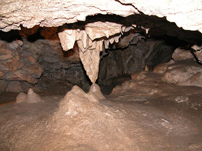
The caves were beautiful, all the rooms and formations were named.
It took us 1 hour 45 minutes to complete the tour.
There are over 500 steps to traverse, many of them wet, slippery, steep, uneven and dimly lit.
Temperatures in the cave were in the low to mid 40's, but the coolness was welcome on a hot day.
The formations are caused by mineral deposits left by dripping water.
Stalactites grow down from the roof of the cave and stalagmites form when stalactites drip on to the floor.
 Formation of a column in progress
When a stalactite meets a stalagmite, a column is formed.
 The ceiling at the top of the spiral staircase
My mother worked at the Oregon Caves for a while when she was in college, a summer job.
After our driving adventures, Steven was so relieved when we hit the highway that he wanted to head for home and skip the caves.
But after the trip he was enthralled, it was very worthwhile, even given our driving adventures.
After we left, we headed for home. We stuck to major highways and did not follow google's advice. He got as far as Redding, CA the first night and drove the rest of the 660 miles home the next day. I put over 3500 miles on the rental car.
All in all it was a great trip. We're looking forward to doing it again in 2 years.
- Kathleen
Labels: Oregon

 The Banana Grove
 Cave Drapery
 Moon Milk
 The Grand Column
 Soda Straws
 Miller's Chapel
 Paradise Lost
 Outside again above the cave


0 Comments:
Post a Comment
<< Home